WhatsApp/Call +9779849643731 (Office) +977 9841289596 (Mobile) or get advise from travel professional
Site Search
Yala Peak and Naya Kanga peak Expedition
-
Trip CodeGHN-Trip-85
-
Duration:21 Days
- Trip Grade Strenuous
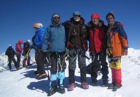
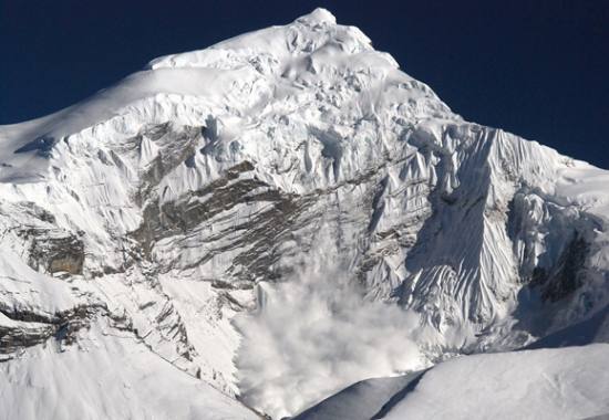
 Yala Peak
About Trip
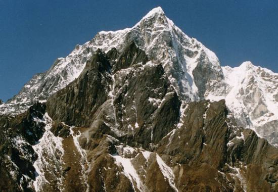
The Langtang Valley is located only 19 miles north of Kathmandu, close to the border of Tibet, below the main crest of the Himalaya. The valley is dominated by Langtang Lirung (7246m), the highest peak in the area. This trek with its optional climbs of Yala Peak and Naya Kanga offers a wonderful introduction to mountaineering in the Himalaya, among some of the most beautiful scenery in the whole of Nepal.
Our trek begins with a 7/8 hour drive to Syabrubesi. Initially we trek through sub-tropical jungle, then dense forest of oak, birch and pine before the valley opens out into alpine meadows and yak pastures. In the spring these high meadows are carpeted with a rich variety of alpine flowers - gentians, violets, edelweiss and primulas to name just a few – and the forests are also in full bloom with rare tree orchids and the colorful rhododendron. The Langtang forests are also known for their wildlife, including red pandas, Himalayan black bear, and wild boar and languor monkeys.
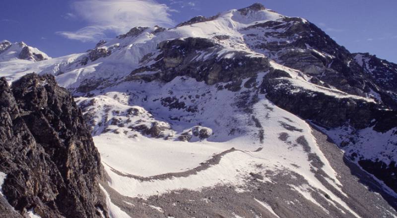
We trek up the valley to Kyangjin where we camp in a superb setting, dominated by the fluted North West face of Kangchenpo, whilst Kyangjin Ri provides a splendid viewpoint. From Kyangjin we move further up the valley to Yala, a small yersa (summer hamlet). Basing ourselves here allows time to walk to the top of Tsergo Ri (5066m), the highest point on a broad flat plateau. The views from here are as spectacular as anywhere in the Himalaya, a 360 degree panorama of snow capped mountains including Langtang Lirung, Pemthang Ri, Langshisha Ri, Dorje Lakpa, and Kangchenpo.
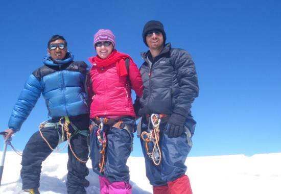
Our base at Yala also provides us with the opportunity to climb Yala Peak (5732m). This is not technically difficult and provides good acclimatization and training for our climb of Naya Kanga (5844m). The climb is straightforward being little more than a walk up steep snow slopes of around 30 degrees. The view from the summit is breathtaking - magnificent snow capped peaks all around and views across to the mountains of Tibet, including Shishapangma.
Fit and acclimatized we move from Yala to our base for Naya Kanga, a camp on moraines below the Kangja La. From here there are good views of the north east ridge of Naya Kanga, the route we will be climbing. The climb is fairly straightforward, though the final snow crest is quite narrow, great fun for those with a head for heights. Once again the views from the summit are spectacular, a fitting climax to a magnificent climb.
For anyone not wishing to climb Yala Peak and Naya Kanga, there is every opportunity to explore the spectacular upper Langtang valley. Our camps are in superb locations, the trekking is not difficult and there are many good options for day walks from our base camps. The trek to and from the Upper Langtang valley is a 'classic' in its own right.
We descend from the upper Langtang Valley as far as Syabru before following a different trail, past Sing Gompa, to the sacred lakes of Gosainkund. We cross the Laurebina La (4610m) and return to Kathmandu through the lovely villages of the Helambu region.
Day to Day Itinerary:
Hide All DaysDay 01: Kathmandu
At Kathmandu international Airport, After Visa formalities complete, we have to come downstairs to collect Luggage and proceed to outside from terminal Building. Please check our Company Name board, Our Guide will be waiting with Guide Nepal Holidays display board at the arrival gate. Upon our arrival at Kathmandu international airport, we will be warmly welcome by our Airport representative guide with Silk scarves as per Sherpa customs.
You will be transfer to hotel by Private Vehicle. Check in at Hotel, free welcome drinks tea/coffee or any cold drinks/Juices. Company Manager will meet you as per your prefer time & will provide detailed Plans and Briefing about the trip. At the Evening we will offer you welcome dinner at best authentic Nepali restaurant where you can enjoy the best Nepali food and cultural show.
Dinner included overnight stay at best hotel in the Kathmandu.
Day 02: Kathmandu- Syabru-Besi(1450M)
Drive to Dhunche and continue on to Syabrubesi via Trisuli Bazaar by private transport. Overnight in Syabrubesi. (4WD is necessary because of the rocky un-asphalted road).
Day 03: Syabrubesi- Lama Hotel
After leaving our hotel we cross the Bhote Kosi river by a suspension bridge towards ‘old’ Syabrubesi, a cluster of houses and a school opposite the river. Another suspension bridge carries us over the south side of the Langtang Khola, this river we will be following upwards for the next couple of days. We climb slowly to Doman (1680m) and continue over a rocky ridge to Landslide Lodge and Hot Spring restaurant; named after a small hot spring on the opposite river bank at 1810 meter. The trail now climbs gently up to Bamboo Lodge where we will enjoy our lunch. Opposite the river we will see near vertical cliffs covered with cactuses. After Bamboo we cross the Langtang Khola on a new suspension bridge to the north bank. The forest becomes sparser and drier on this side of the river, consisting mainly of scrub oaks and nettles. We climb steeply on a good trail to Rimche (2510m). We have now finished most of today’s climbing and descend slowly to our selected teahouse where we will spend the night (6 hrs).
Day 04: Lama Hotel- Langtang
The day starts with a gentle climb, but it soon becomes steeper, climbing through a forest of hemlocks, oaks, maples and rhododendron. Beautiful views of Langtang Lirung (7246m) can be seen from the trail. After little more then an hour we pass two lodges in the forest at Gumanchok (2800m), from where we climb to a Nepal army post and a national park checkpoint at Ghora Tabela (2970m). The trail asvends gradually, as the valley becomes wider. We will pass a few teashops at Thangshyap at 3140 meter, where we will have our lunch. The route is now in open country, and passes many mani stones, water-driven prayer wheels and a few scattered Tamang villages before arriving in Langtang. This is a small village consisting of guesthouses and yak farms. The surrounding fields containing buckwheat, potatoes, wheat, turnips and barley have typical stone fencing walls (5 hrs).
Day 05: Langtang- Kyanjin Gompa
Walking through the village of Langtang we will pass many stone mani walls, covered with Tibetan inscriptions to please the gods. It then climbs up gradually past the small villages of Mumdu and Sindum. The trail continues through yak pastures. After crossing the Langtang Khola to its south bank we climb up through a landscape scattered with large boulders to a moraine where we will have the first views of Kyanjin Gompa ahead of us, and the dramatic icefall flowing from Langtang Lirung and Langtang Kinshung (6781m) north of us. Our route weaves through the large boulders to a gompa and from here it’s a short descent to Kyanjin Gompa. It is easy to reach our destination before lunch, allowing time to acclimatize and explore the surroundings. One of the options is a hike to one of the good viewpoints. To the north of Kyanjin Gompa is the Kyanjin Ri (4773m), which is a two-hour climb. From here we have a great view over the mountain range in the west, including Langshisha Ri (6370m), Gang Chhenpo (6388m) and Dorje Lakpa (6966m) (3 hrs, to the viewpoint and back is about another 3 hrs).
Day 06: Kyanjin Gompa
Today we stay in Kyajin Gompa to explore a bit more of the Langtang valley. Our trail descends a little to the old abandoned VTOL airstrip, and then follows the river upstream to some herders’ huts at Jatang (3840m). We will continue to climb slowly up the valley until we are surrounded by the mountain amphitheatre with Langshisha Ri, Langshisha Kharka and Dorje Lakpa towering high above us. We will descent back to Kyajin Gompa after our lunch.
Day 07: Kyangjin To Yala [4641m]
From Kyangjin we continue further up the valley, climbing above the Langtang Khola and contouring around the hillside to the yersa at Yala. From our camp here there are tremendous views towards the peaks of Dorje Lakpa [7000m], Kangchenpo [6400m] and Lonpo Gang [7100m].
Day 08: In Yala
From our camp at Yala it is only a short way to the top of Tsergo Ri [5066m]. This is an 'easy' walk to the prayer flags and mani stones marking the summit, the highest point on a broad flat plateau. The views all around are spectacular, a 360 degree panorama of snow capped peaks including Langtang Lirung, Kimshun, Yanza Tsenji, Langtang Ri, Pemthang Ri, Langshisha Ri, Dorje Lakpa, Kangchenpo and Naya Kanga.
Day 09: Climb Of Yala Peak
Our base at Yala provides us with the opportunity to climb Yala Peak, a glaciated peak to the north east of Yala. The climb is not difficult and provides good acclimatisation and training for our climb of Naya Kanga. The climb is straightforward being little more than a walk up steep snow slopes of around 30 degrees. Ice axe and crampons will be needed and most of the climb will involve walking roped together up the glacier. This climb is a superb introduction to mountaineering in the Himalaya with magnificent mountain scenery all around and views across to the mountains in nearby Tibet, including Shishapangma.
Day10: Yala To Naya Kanga Base Camp [5100m]
We retrace our route down the valley towards Kyangjin and cross the Langtang Khola before following a trail uphill towards the Kangja La. Some steep scrambling through boulder fields eventually leads to a camp on moraines below the Kangja La. The campsite offers good views of our route up Naya Kanga, as well as views of Shishapangma.
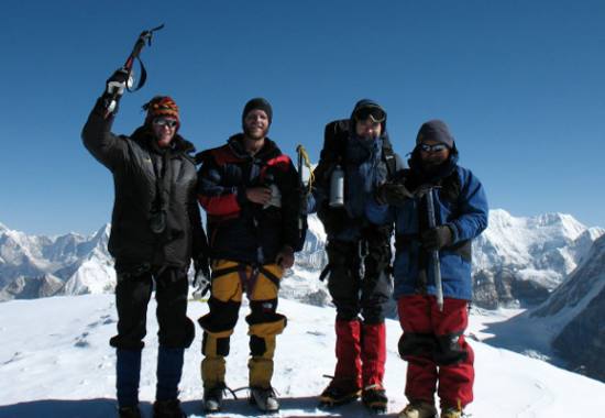
Day11: Climb Of Naya Kanga [5844m]
Two days have been allowed for the climb. One may be used as a rest day before climbing Naya Kanga.An early start will take us towards the Kangja La before following a terrace to cross the glacier and reach the foot of the north east ridge. This ridge provides a long steep snow climb with superb views down both sides. The final snow crest is quite narrow and will be great fun for those with a head for heights. The views from the summit are superb and many of Nepal's well known mountains can be identified. A long steep descent to camp will leave us tired but very satisfied with our efforts. For those not wishing to climb Yala Peak and /or Naya Kanga, our base at the head of the Langtang valley is in a superb setting, as spectacular as anywhere in the Himalaya and there is ample time to explore the upper Langtang valley with many good options for day walks from our base camps.
Day12: To Lama Hotel [2748m]
From Kyangjin we retrace our route, following the Langtang Khola to Langtang village and on to Ghora Tabela. After lunch we continue the steep descent to Lama Hotel.
Day13: Lama Hotel To Syabru [2130m]
We continue retracing our steps to Syabru.
Day14: Syabru To Sing Gompa [3254m]
From Syabru it is a steep climb through forests of oak, firs and rhododendrons to gain a ridge. From here it is only a short descent to Sing Gompa. Here there is a Buddhist monastery and a small cheese factory.
Day15: Sing Gompa To Gosaikund [4336m]
From Sing Gompa we climb a ridge to gain the main Gosainkund trail. There are good views across Langtang valley to Langtang Lirung. To the west there are dramatic views of Himalchuli, Ganesh Himal and Manaslu. Eventually the trail descends from the ridge to the first of three lakes, Saraswati Kund. The second lake in the chain is named Bhairab Kund, and the third, Gosainkund. This lake is particularly sacred and a place of pilgrimage in the summer. According to legend this lake was created by Shiva when he pierced a glacier with his trident to obtain water, quenching his thirst after taking some poison.
Day16: Gosaikund To Gopte [3359m]
The trail leaves Gosainkund and climbs through rugged country, past four more small lakes to Laurebina La at 4610m. We then descend steeply to camp near Gopte.
Day17: Trek To Tharepati [3285m]
We continue descending along the ridge, through rhododendron and juniper forests and past herders' huts to a stream before climbing to Tharepati, a group of herders' huts at 3490m. From Tharepati the trail gradually descends through pine and rhododendron forest with good views down into the Helambu valley and across to Jugal Himal and Numbur in the Solu Khumbu.
Day18: Trek To Khutumsang [2125m]
From Mangan Kharka it is a short climb to cross a ridge before following a very easy trail, through forest with superb views across to Numbur, Jugal Himal and many other snow capped peaks. From Kutumsang we climb to a pass at 2620m., before descending to the Tamang village of Gulphu Bhanjyang. We camp beyond Gulphu Bhanjyang, on a ridge with splendid views, stretching from the Annapurnas and Manaslu in the west to Numbur in the east.
Day19: Trek To Chisopani [2194m]
From our camp it is an easy climb to cross a pass at 2470m before descending to Pati Bhanjyang, a large Tamang village with a few shops and a police check post. From here it is a 2 hour climb to Chisopani and our camp.
Day20: Chisopani To Kathmandu [1450m]
From Chisopani the trail passes through meadows and cultivated fields then climbs through oak and rhododendron forest to Burlang Bhanjyang. From here there are magnificent views, from Annapurna in the west to Ganesh Himal and Numbur in the east. This ridge marks the northern rim of the Kathmandu Valley. We now begin descending steeply through dense forest of oak, pine and rhododendron to cross a dam and then follow a large water pipe which supplies much of the water for Kathmandu. Soon we are down into Sundarijal where we pick up transport into Kathmandu.
Day21: Departure
Morning free for last Minute shopping or time as your own.
Our driver and airport representative drive you to the airport in time for your flight back home. We ensure that you leave Kathmandu with cherishing memory and an experience of a lifetime.
Price Include:
- KTM International Airport Arrival & Departure Transfer by Private Car/van/ Hiace/Private Bus
- Total 2 Nights DELUXE Accommodations on B/B Plan Twin Sharing in Kathmandu
- Land Transportation((KTM-SYABRUBESI) By Comfortable LANDCRUISER/JEEP(4WD) as per Group size for Guests & Staffs- Approx 7-8 hrs Drive
- Land Transportation( SUNDARIJAL- KATHMANDU) By Comfortable CAR/HIACE as per Group size for Guests & Staffs- Approx 1 hrs Drive
- English Speaking experienced Sherpa Govt. Trained/Licensed Holder Guide for whole Trek( In order to make 100% successful summit, we provide 1 Trek cum Climbing Guide for group of 1-2 Pax, 2 Climbing Guide for Group of 3-5 Pax, 3 climbing Guide for group of 6- 10 Pax, 4 Climbing Guide for group of 11-15 pax basis)
- Porters (One porter for 2 Person basis, Max 30 KGS per Porter) from Kathmandu-Whole Trek-Kathmandu
- Lang tang National Park fee & Other trek Documentations
- Full Board basis Meals (Breakfast, Lunch & Dinner- Self Lodges Menu Choice) as per above Itinerary
- Best selected Tea house Lodge/Guest houses Accommodations in Twin/single Sharing( single bed room for single person & those who wish to Have single room paying single supplement charge) basis in Whole Trek
- Insurance, Daily Wages, Equipments and all meals & Lodges of Porters and Guide in Whole Trek
- First Aid Kid Box( for Normal Treatment only)
- Emergency helicopter rescue Evacuation Coordination (This is only in case of Emergency condition of guests, however all guests are responsible to pay helicopter Evacuation Charge- US$ 2000 per/Hour if necessary. So all our Valued guests are kindly requested to make sure that you have required travel Insurance which will cover this expenses in case needed)
- Naya kanga Peaks Expedition Permit fees, Yala peak Climbing Fees
- Equipments Charge of Climbing Sherpa for 2 peaks
- Garbage Clearance Deposit to NMA( we will pay our self for this Deposit)
- 4 Nights Tented Accommodation, all meals during climbing, kitchen utensils, cooking Equipments
- Government taxes & Other Applicable Fees
Price Exclude:
- International Airfare to and from your country
- Nepal Visa fee: Nepal entry visa (US$ 25 or equivalent foreign currency for 15 days, US$ 40 or equivalent foreign currency for 30 days & US$ 100 or equivalent foreign currency for 90 days. you will also require 2 passport size photos.)
- Travel & Health Insurance- Emergency Helicopter Rescue Insurance (Most recommended)
- Lunch & Dinner in Kathmandu - keep $ 5 to 10 for per meal in Tourist Restaurant
- Any Alcoholic Drinks, Hot drinks Cold Drinks, Boiled & Mineral Water, Beverages, deserts Etc in Trek
- Tips for Guide & Porter( Not mandatory but expected)
- Hot Shower, Battery Charges( Available in Trek with Extra cost or Free in some lodges)
- Unforeseen Cost such as Flight Cancellation or Delayed, Sick in Trek, and Helicopter rescue in Trek. Cost due to bad weather etc which is out of our control
- Any Other Cost, which is not mentioned in Cost Includes Items as Above
Quick Contact
Related Packages
-
Island Peak Climbing
- Days 19
- Min Person from 2 Person +
- Trip Grade Strenuous
-
Lobuche East Peak Climbing
- Days 19
- Min Person from 2 Person +
- Trip Grade Strenuous
-
Mera Peak Climbing
- Days 17
- Min Person from 2 Person +
-
Mera peak and Island peak expedition
- Days 27
- Min Person from 2 Person & above
- Trip Grade Strenuous
-
Lobuche East Peak- Island Peak
- Days 27
- Min Person from 2 Person +
- Trip Grade Strenuous
-
Chulu East Peak Climbing
- Days 19
- Min Person from 2 Person +
- Trip Grade Strenuous